Coordinate Data Collection with Custom Layers
Collect, structure, and synchronize coordinate data with precision—whether you're online or offline. Ideal for field teams, surveyors, engineers, and urban planners.
Create and Customize Your Own Data Layers
With Coordinator, users can create personalized data layers to organize spatial elements such as points, lines, and polygons. Whether you’re mapping streetlights, pipelines, land parcels, or building perimeters, each layer can be customized to fit your data model.
Each layer supports attributes like name, type, notes, and custom fields. You have full control over how your spatial data is structured, stored, and visualized. Layers can be grouped by project, region, or category, allowing clear separation and filtering of datasets.
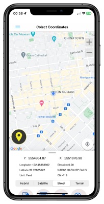
You can also change the visual style of features—selecting colors, icons, and drawing tools to fit your workflow.
Cloud-Connected Collaboration in Real Time
Coordinator is more than a solo tool—it’s a collaborative platform. Thanks to cloud integration, multiple users can work on the same project and the same data layers in real time. This is ideal for teams who are working on-site while others monitor or update from the office.
All edits, new entries, or deletions are instantly synchronized across authorized devices. Changes made by one user are immediately visible to all other team members, ensuring data consistency and reducing the need for repeated exports and merges.
You can assign team roles, manage permissions, and share specific layers with selected colleagues. This makes Coordinator ideal for municipal mapping projects, environmental research, and utility asset tracking.
Geometry Types You Can Work With
- 📍 Point: Use for individual items like trees, signs, poles, or benches.
- 📏 Line: Use to map roads, pipelines, utility lines, or trails.
- 📐 Polygon: Ideal for marking parcels, land areas, buildings, zones, and boundaries.
You can add multiple geometry types in the same session, switch modes on the fly, and later filter or export by type. This flexible geometry support enables accurate modeling of complex spatial situations.
Get Started with the Coordinator App
Download Coordinator today and unlock powerful field data collection tools with cloud collaboration built-in.